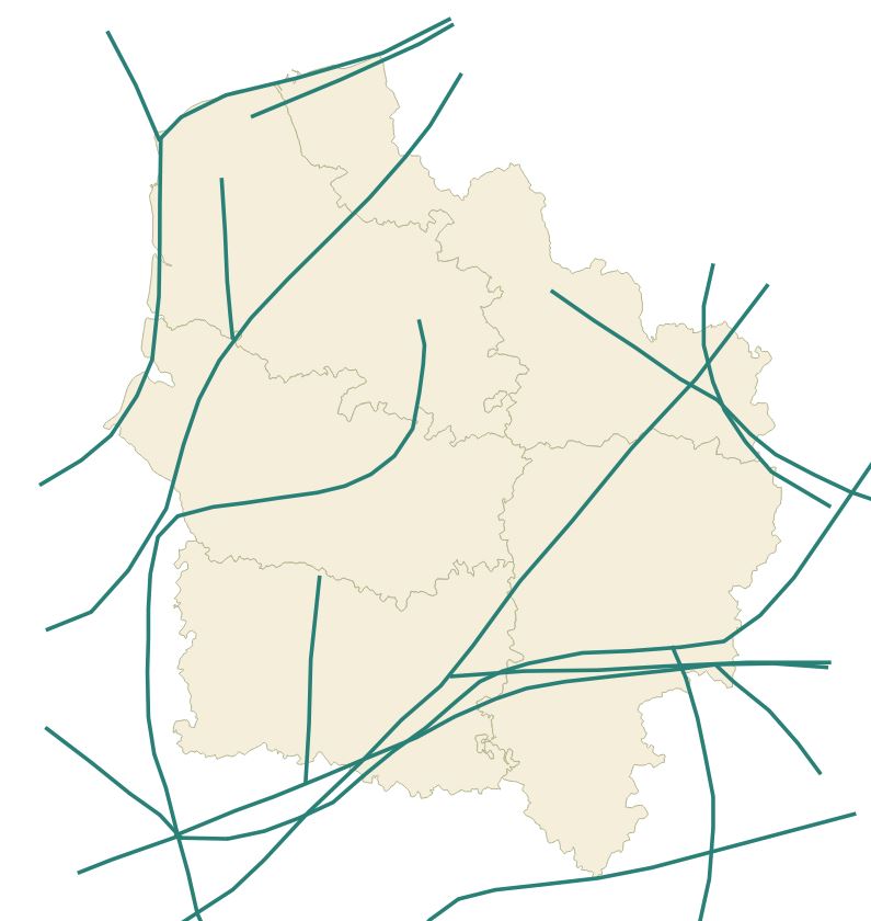
Continuités écologiques d'importance nationale (ONTVB) (cer_ontvb) - SRADDET Hauts-de-France 2020
Représentation des ONTVB (orientations nationales trame verte et bleue) qui permettent une déclinaison cohérente de la trame verte et bleue (enjeu des continuités écologiques) sur le territoire régional.
Cette donnée est la représentation figée à la date de vote du SRADDET (approuvé par arrêté préfectoral le 4 août 2020)
default-legacy
- Date (Creation)
- 2020-10-27
- Date (Revision)
- 2021-01-14
- Citation identifier
- fr-200053742/2020/sraddet/ontvb
- Status
- Completed
- Point of contact
-
Organisation name Individual name Electronic mail address Role Région Hauts-de-France
Point of contact
- Maintenance and update frequency
- As needed
- Keywords
-
-
ORIENTATION NATIONALE
-
SRADDET
-
TRAME VERTE
-
AMENAGEMENT DU TERRITOIRE
-
TRAME BLEUE
-
ONTVB
-
SCHEMA REGIONAL D'AMENAGEMENT DE DEVELOPPEMENT DURABLE ET D'EGALITE DES TERRITOIRES
-
-
Thèmes - SIG - HdF
-
-
AMENAGEMENT
-
-
GEMET - INSPIRE themes, version 1.0
-
-
Unités administratives
-
-
Région
-
-
HAUTS-DE-FRANCE
-
-
Thématiques région
-
-
AMENAGEMENT
-
-
Thématiques région
-
-
AMENAGEMENT
-
-
Territoires
-
-
AISNE (Département)
-
OISE (Département)
-
SOMME (Département)
-
NORD (Département)
-
PAS DE CALAIS (Département)
-
- Use limitation
-
Utilisation libre sous réserve de mentionner la source (a minima le nom du producteur) et la date de sa dernière mise à jour
- Use limitation
-
Données ouvertes
- Access constraints
- Other restrictions
- Use constraints
- Other restrictions
- Denominator
- 100000
Spatial resolution
- Language
-
fre
- Character set
- UTF8
- Topic category
-
- Boundaries
))
- Distribution format
-
Name Version
- Distributor contact
-
Organisation name Individual name Electronic mail address Role Conseil régional Hauts-de-France
Point of contact
- OnLine resource
-
Protocol Linkage Name OGC:WMS
https://qgisserver.hautsdefrance.fr/cgi-bin/qgis_mapserv.fcgi?MAP=/var/www/data/qgis/applications/sraddet_2020_08.qgz cer_ontvb
OGC:WFS
https://qgisserver.hautsdefrance.fr/cgi-bin/qgis_mapserv.fcgi?MAP=/var/www/data/qgis/applications/sraddet_2020_08.qgz cer_ontvb
WWW:LINK-1.0-http--link
https://sig.hautsdefrance.fr/ext/opendata/Sraddet2020/precisions_biodiversite.pdf Recommandations d'usage
- Hierarchy level
- Dataset
Conformance result
- Date (Publication)
- 2000-01-01
- Explanation
-
-- Information sur l'évaluation de la conformité (non INSPIRE) --
- Pass
- Statement
-
Donnée figée à la date de vote du SRADDET (approuvé par arrêté préfectoral le 4 août 2020)
Metadata
- File identifier
- 23bb3ee1-0cd1-43a4-b859-9aa90ca5419a XML
- Metadata language
- Français
- Character set
- UTF8
- Hierarchy level
- Dataset
- Hierarchy level name
-
Précision sur le niveau de hiérarchie (non INSPIRE)
- Date stamp
- 2025-05-07T14:27:31.495717Z
- Metadata standard name
-
ISO 19115:2003/19139
- Metadata standard version
-
1.0
- Metadata author
-
Organisation name Individual name Electronic mail address Role Région Hauts-de-France
Point of contact
Overviews
Spatial extent
Provided by