
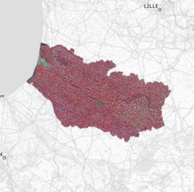
Orthophotographie du Département de la Somme (2008) - rayonnement infrarouge
Orthophotographie infrarouge du Département de la Somme datant d'août 2009, réalisée à partir de prises de vues aériennes numériques (pixel 20cm) de mai 2008 dans le système de projection Lambert 93.
Ces données sont cofinancées par l’Union européenne. L’Europe s’engage en Picardie avec le Fonds européen de développement régional.
default-legacy
- Date (Creation)
- 2008-09-23T17:24:00
- Citation identifier
- https://www.geo2france.fr/geonetwork/srv/fre/catalog.search#/metadata/28f50d8a-fa06-48f2-b6e0-0774f9763a6b
- Point of contact
-
Organisation name Individual name Electronic mail address Role Géo2France
Point of contact État
Point of contact Région Hauts-de-France
Point of contact Département de la Somme
Point of contact METRIS
Resource provider METRIS SAS
THEO Nathalie
Resource provider
-
GEMET - INSPIRE themes, version 1.0 INSPIRE themes
-
-
Ortho-imagerie
-
-
GEMET - Concepts, version 2.4
-
-
photographie
-
photographie aérienne
-
- Theme
-
-
orthophotographies
-
images aériennes
-
- Use limitation
-
Utilisation selon CONTRAT DE LICENCE DE DROIT D’USAGE signé entre le CG80 et METRIS SAS
- Access constraints
- License
- Use constraints
- License
- Aggregate Datasetindentifier
- a59e1ee7-e1ce-4efa-8f85-7b3bd90560fd
- Association Type
- Cross reference
- Aggregate Datasetindentifier
- e025b6ed-6f01-43d5-91c6-33d0598ccf38
- Association Type
- Cross reference
- Spatial representation type
- Grid
- Distance
- 0.2 m
- Language
- Français
- Topic category
-
- Imagery base maps earth cover
- Description
-
Département de la Somme
))
- Reference system identifier
- Lambert 93
- OnLine resource
-
Protocol Linkage Name OGC:WMS https://www.geo2france.fr/geoserver/geo2france/ows somme_ortho_2008_ir
- Hierarchy level
- Dataset
- Statement
-
Date des prises de vues : les 07, 08, 09, 19 et 21 mai 2008
Caméra : UltraCAM X de Vexcel (pixel sol de 20cm)
Avion : Piper Aztec bi-moteur 2x250cv (IMAO)
Stéréopréparation : 76 sites mesurés par GPS Leica 1200 avec connexion GSM au réseau ORPHEON
Aérotriangulation : MATCH AT
MNT : MATCH-AT et DTMaster
Ortho : OrthoVista de INPHO
Produit fini : Découpage 2000m x 2000m
Nombre de dalles : 1833 dalles
Format des fichiers : TIF (+TFW) et JPEG 2000
Metadata
- File identifier
- 28f50d8a-fa06-48f2-b6e0-0774f9763a6b XML
- Metadata language
- Français
- Character set
- UTF8
- Hierarchy level
- Dataset
- Hierarchy level name
-
Jeu de données
- Date stamp
- 2023-01-26T09:05:02.999561Z
- Metadata standard name
-
ISO 19115
- Metadata standard version
-
1.0
- Metadata author
-
Organisation name Individual name Electronic mail address Role METRIS SAS
Resource provider METRIS SAS
BAILLY Olivier
Resource provider
)))