Canal Seine Nord Europe (projet de tracé) - SRADDET 2020
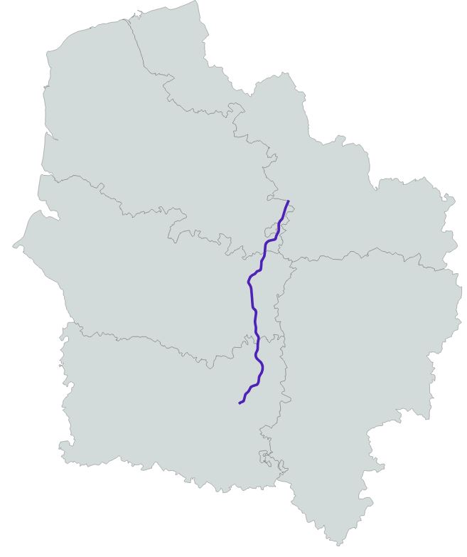
Tracé prévu du Canal Seine Nord Europe qui reliera l’Oise au canal Dunkerque-Escaut, de Compiègne à Aubencheul-au-Bac (près de Cambrai).
Ce canal à grand gabarit européen permettra d'accueillir des bateaux d’une longueur allant jusque 185 mètres et jusque 11,40 mètres de large, pouvant contenir 4 400 tonnes de marchandises, soit l'équivalent de 220 camions.
Cette donnée est la représentation figée à la date de vote du SRADDET (approuvé par arrêté préfectoral le 4 août 2020)
Plus d'informations sur le site du CSN :
default-legacy
- Date (Creation)
- 2020-06-24
- Date (Revision)
- 2021-01-14
- Citation identifier
- fr-200053742/2019/sraddet/transp_projet_canal_sne_trace
- Status
- Completed
- Point of contact
-
Organisation name Individual name Electronic mail address Role Région Hauts-de-France
Point of contact
- Maintenance and update frequency
- As needed
- Keywords
-
-
SCHEMA REGIONAL D'AMENAGEMENT DE DEVELOPPEMENT DURABLE ET D'EGALITE DES TERRITOIRES
-
SRADDET
-
INFRASTRUCTURE
-
RESEAU FLUVIAL
-
POLITIQUE REGIONALE
-
AMENAGEMENT DU TERRITOIRE
-
CANAL SEINE NORD EUROPE
-
NAVIGATION
-
TRANSPORT
-
DONNEE OUVERTE
-
-
Thèmes - SIG - HdF
-
-
TRANSPORT
-
-
GEMET - INSPIRE themes, version 1.0
-
-
Réseaux de transport
-
-
Région
-
-
HAUTS-DE-FRANCE
-
-
Territoires
-
-
AISNE (Département)
-
OISE (Département)
-
SOMME (Département)
-
NORD (Département)
-
PAS DE CALAIS (Département)
-
-
Thématiques région
-
-
TRANSPORT
-
- Use limitation
-
Utilisation libre sous réserve de mentionner la source (a minima le nom du producteur) et la date de sa dernière mise à jour
- Use limitation
-
Données ouvertes
- Use constraints
- Other restrictions
- Denominator
- 150000
Spatial resolution
- Language
-
fre
- Character set
- UTF8
- Topic category
-
- Transportation
))
Vertical extent
- Distribution format
-
Name Version
- Distributor contact
-
Organisation name Individual name Electronic mail address Role Conseil régional Hauts-de-France
Service SIG et appui à la connaissance
Point of contact
- OnLine resource
-
Protocol Linkage Name OGC:WMS
https://qgisserver.hautsdefrance.fr/cgi-bin/qgis_mapserv.fcgi?MAP=/var/www/data/qgis/applications/sraddet_2020_08.qgz transp_projet_canal_sne_trace
OGC:WFS
https://qgisserver.hautsdefrance.fr/cgi-bin/qgis_mapserv.fcgi?MAP=/var/www/data/qgis/applications/sraddet_2020_08.qgz transp_projet_canal_sne_trace
- Hierarchy level
- Dataset
Conformance result
- Title
-
INSPIRE Data Specification on Administrative Units - Guidelines v3.0.1
- Date (Publication)
- 2020-06-10
- Explanation
-
-- Information sur l'évaluation de la conformité (non INSPIRE) --
- Pass
- Statement
-
Source : VNF (Voies Navigables de France), VNF Hauts-de-France
Donnée figée à la date de vote du SRADDET (approuvé par arrêté préfectoral le 4 août 2020)
Metadata
- File identifier
- 34c334f0-5f35-4018-8c3c-e9809d4af7c0 XML
- Metadata language
- Français
- Character set
- UTF8
- Hierarchy level
- Dataset
- Hierarchy level name
-
Précision sur le niveau de hiérarchie (non INSPIRE)
- Date stamp
- 2025-09-29T13:02:25.029238Z
- Metadata standard name
-
ISO 19115:2003/19139
- Metadata standard version
-
1.0
- Metadata author
-
Organisation name Individual name Electronic mail address Role Région Hauts-de-France
Point of contact
)))