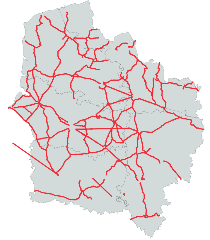
Réseau Routier d’Intérêt Régional (RRIR) - SRADDET 2020
Tracé du Réseau Routier d’Intérêt Régional (RRIR) de la Région des Hauts-de-France (dernière mise à jour janvier 2020)
Disposition créée par la loi NOTRe, le RRIR est un composé d'axes routiers qui constituent des itinéraires d'intérêt régional permettant de garantir la cohérence, l'efficacité du réseau routier ainsi que la sécurité des usagers au sein de la région élargie.
Cette donnée est la représentation figée à la date de vote du SRADDET (approuvé par arrêté préfectoral le 4 août 2020)
default-legacy
- Date (Creation)
- 2020-06-03
- Date (Revision)
- 2021-01-14
- Citation identifier
- fr-200053742/2019/srradet/rrir
- Status
- Completed
- Point of contact
-
Organisation name Individual name Electronic mail address Role Région Hauts-de-France
Point of contact
- Maintenance and update frequency
- As needed
- Keywords
-
-
SCHEMA REGIONAL D'AMENAGEMENT DE DEVELOPPEMENT DURABLE ET D'EGALITE DES TERRITOIRES
-
SRADDET
-
INFRASTRUCTURE
-
RESEAU ROUTIER
-
POLITIQUE REGIONALE
-
AMENAGEMENT DU TERRITOIRE
-
TRANSPORT ROUTIER
-
DONNEE OUVERTE
-
-
Thèmes - SIG - HdF
-
-
TRANSPORT
-
-
GEMET - INSPIRE themes, version 1.0
-
-
Réseaux de transport
-
-
Région
-
-
HAUTS-DE-FRANCE
-
-
Départements
-
-
PAS-DE-CALAIS
-
AISNE
-
NORD
-
OISE
-
SOMME
-
- Use limitation
-
Utilisation libre sous réserve de mentionner la source (a minima le nom du producteur) et la date de sa dernière mise à jour
- Use limitation
-
Données ouvertes
- Use constraints
- Other restrictions
Spatial resolution
- Denominator
- 5000
Spatial resolution
- Language
-
fre
- Character set
- UTF8
- Topic category
-
- Transportation
))
- Distributor contact
-
Organisation name Individual name Electronic mail address Role Conseil régional Hauts-de-France
Point of contact
- OnLine resource
-
Protocol Linkage Name OGC:WMS
https://qgisserver.hautsdefrance.fr/cgi-bin/qgis_mapserv.fcgi?MAP=/var/www/data/qgis/applications/sraddet_2020_08.qgz transp_rrir
OGC:WFS
https://qgisserver.hautsdefrance.fr/cgi-bin/qgis_mapserv.fcgi?MAP=/var/www/data/qgis/applications/sraddet_2020_08.qgz transp_rrir
- Hierarchy level
- Dataset
Conformance result
- Date (Publication)
- 2020-06-10
- Explanation
-
-- Information sur l'évaluation de la conformité (non INSPIRE) --
- Pass
- Statement
-
Données Mars 2020
Source : BD Topo
Donnée figée à la date de vote du SRADDET (approuvé par arrêté préfectoral le 4 août 2020)
Metadata
- File identifier
- 35c79b57-9e7f-4e70-b9e9-94c65908cc46 XML
- Metadata language
- Français
- Character set
- UTF8
- Hierarchy level
- Dataset
- Hierarchy level name
-
Précision sur le niveau de hiérarchie (non INSPIRE)
- Date stamp
- 2025-01-24T15:05:46.109551Z
- Metadata standard name
-
ISO 19115:2003/19139
- Metadata standard version
-
1.0
- Metadata author
-
Organisation name Individual name Electronic mail address Role Région Hauts-de-France
Point of contact
Overviews
Spatial extent
Provided by