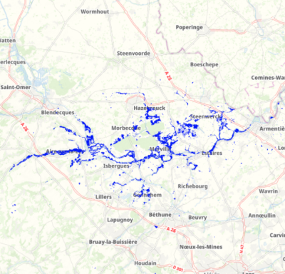
Extension maximale potentielle des inondations de novembre 2023 sur le bassin versant de la Lys
Il s’agit de l’enveloppe potentielle maximale des inondations que le bassin versant de la Lys a eu en novembre 2023. Cette donnée est issue de l’acquisition d’images satellites les 10, 11, 12 et 15 novembre 2023.
default-legacy
- Date (Publication)
- 2024-02-01T11:30:00
- Citation identifier
- https://www.symsagel.fr/2020/cnec
- Status
- Completed
- Point of contact
-
Organisation name Individual name Electronic mail address Role SYMSAGEL
symsagel@@sage-lys.net
Point of contact
-
GEMET - INSPIRE themes, version 1.0
-
-
Hydrographie
-
Caractéristiques géographiques météorologiques
-
-
Départements
-
-
NORD
-
PAS-DE-CALAIS
-
- Theme
-
-
SYMSAGEL
-
DONNEE OUVERTE
-
CRUES
-
-
EPCI
-
-
CA de Béthune-Bruay, Artois-Lys Romane
-
CA de Lens - Liévin
-
CC de Flandre Intérieure
-
CA du Pays de Saint-Omer
-
CC Flandre Lys
-
CC des Campagnes de l'Artois
-
Métropole Européenne de Lille
-
- Access constraints
- Other restrictions
- Other constraints
- Pas de restriction d’accès public
- Use constraints
- Other restrictions
- Other constraints
-
Licence Ouverte version 2.0 https://www.etalab.gouv.fr/wp-content/uploads/2017/04/ETALAB-Licence-Ouverte-v2.0.pdf
- Distance
- 20 m
- Denominator
- 1000
- Language
-
fre
- Character set
- UTF8
- Topic category
-
- Inland waters
- Climatology, meteorology, atmosphere
- Description
-
France
- Description
-
HAUTS-DE-FRANCE
))
- Distribution format
-
Name Version shape
QGIS 3.10.4
- OnLine resource
-
Protocol Linkage Name OGC:WMS https://www.geo2france.fr/geoserver/symsagel/ows xxtension_maximale_approchee_Nov23
OGC:WFS https://www.geo2france.fr/geoserver/symsagel/ows symsagel:xxtension_maximale_approchee_Nov23
- Hierarchy level
- Dataset
Conformance result
- Date (Publication)
- 2020-04-07
- Explanation
-
La couche est validée en interne et en attente de validation externe par les partenaires techniques.
- Pass
- No
- Statement
-
Données acquises et traitées par le SERTIT.
Metadata
- File identifier
- 503ec1b5-e3aa-43c8-a895-ccf9a38ff58f XML
- Metadata language
- Français
- Character set
- UTF8
- Hierarchy level
- Dataset
- Hierarchy level name
-
Précision sur le niveau de hiérarchie (non INSPIRE)
- Date stamp
- 2024-02-06T16:06:59.750611Z
- Metadata standard name
-
ISO 19115:2003/19139
- Metadata standard version
-
1.0
- Metadata author
-
Organisation name Individual name Electronic mail address Role SYMSAGEL
Sarah DUVERNEY
Point of contact SYMSAGEL
Xavier LEGRAIN
Point of contact
Overviews
Spatial extent
Provided by
