Occupation du sol 1998 (Nord - Pas-de-Calais)
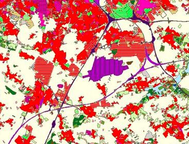
Mode d'occupation des sols en Nord - Pas-de-Calais pour l'année 1998. Base de données construite par exploitation en photo-interprétation assistée par ordinateur de photographies infra-rouge couleur à 50 cm de résolution. Nomenclature en 55 postes.
default-legacy
- Date (Creation)
- 1998-01-01
- Date (Revision)
- 2019-10-01
- Citation identifier
- fr-200053742/2020/occsol_npdc_1998
- Point of contact
-
Organisation name Individual name Electronic mail address Role Région Hauts-de-France
Point of contact
- Maintenance and update frequency
- As needed
- Keywords
-
-
OCCUPATION DU SOL
-
OCS
-
SOL
-
AMENAGEMENT DU TERRITOIRE
-
URBANISME
-
DONNEE OUVERTE
-
-
GEMET - INSPIRE themes, version 1.0
-
-
Usage des sols
-
-
Territoires
-
-
Nord-Pas-de-Calais (ancienne région)
-
-
Thématiques région
-
-
AMENAGEMENT
-
- Use limitation
-
Utilisation libre sous réserve de mentionne la date et la source (a minima le nom du producteur)
- Access constraints
- Other restrictions
- Use constraints
- Other restrictions
- Denominator
- 25000
Spatial resolution
- Language
-
fre
- Character set
- UTF8
- Topic category
-
- Planning cadastre
))
- Distribution format
-
Name Version
- Distributor contact
-
Organisation name Individual name Electronic mail address Role Région Hauts-de-France
Point of contact
Digital transfer options
- OnLine resource
-
Protocol Linkage Name OGC:WMS
https://qgisserver.hautsdefrance.fr/cgi-bin/qgis_mapserv.fcgi?MAP=/var/www/data/qgis/applications/occupation_du_sol.qgs ocs_npdc_1998
OGC:WFS
https://qgisserver.hautsdefrance.fr/cgi-bin/qgis_mapserv.fcgi?MAP=/var/www/data/qgis/applications/occupation_du_sol.qgs ocs_npdc_1998
WWW:LINK-1.0-http--link
https://sig.hautsdefrance.fr/ext/opendata/Amenagement/Ocsfin98_npdc.zip Shapefile Occupation du sol 98 (Ocsfin98_npdc)
WWW:LINK-1.0-http--related
https://sig.hautsdefrance.fr/ext/opendata/Amenagement/OCS/D_ocsgen98.htm Dictionnaire de la donnée Occupation du sol 1998 - niveau généralisé
WWW:LINK-1.0-http--related
https://sig.hautsdefrance.fr/ext/opendata/Amenagement/OCS/D_ocsfin98.htm Dictionnaire de la donnée Occupation du sol 1998 - niveau fin
- Hierarchy level
- Dataset
Conformance result
- Title
-
-- Titre d'une spécification à laquelle la série de données est conforme ou non --
- Date (Publication)
- 2000-01-01
- Explanation
-
-- Information sur l'évaluation de la conformité (non INSPIRE) --
- Pass
- Statement
-
Traitement des photographies et génération de 55 thèmes d'occupation du sol et généralisation en 6 thèmes. Recalage et correction thématique de l'occupation du sol à partir des photos aériennes de 2005
Metadata
- File identifier
- 67704a97-c15a-4e90-91ba-c616b5cfed51 XML
- Metadata language
- Français
- Character set
- UTF8
- Hierarchy level
- Dataset
- Hierarchy level name
-
Précision sur le niveau de hiérarchie (non INSPIRE)
- Date stamp
- 2026-05-06T13:05:08.735533Z
- Metadata standard name
-
ISO 19115:2003/19139
- Metadata standard version
-
1.0
- Metadata author
-
Organisation name Individual name Electronic mail address Role Conseil régional Hauts-de-France
Point of contact
)))