• Géo2France
  •  
  •  
  •  

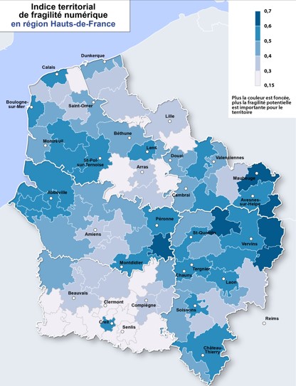
Indice de fragilité numérique en Hauts-de-France (fin 2021)

Un indice de fragilité numérique a été établi (en se basant sur plusieurs indicateurs) afin d'identifier en région les enjeux territoriaux d'aménagement (besoins d'infrastructures, de services publics...) et les enjeux de médiation (accompagnement des publics)

default-legacy

Date (Creation)
2022-03-21
Date (Publication)
2022-03-30
Date (Revision)
2022-03-29
Citation identifier
fr-200053742/2022/societe/indice_fragilite
Status
Completed
Point of contact
Organisation name Individual name Electronic mail address Role

Région Hauts-de-France

opendata@hautsdefrance.fr

Point of contact

Thèmes - SIG - HdF

  • SOCIETE

Keywords
  • EMPLOI

  • NUMERIQUE

  • FORMATION

  • EPCI

  • TERRITOIRE

  • POLITIQUE PUBLIQUE

  • INFORMATIQUE

  • SERVICE PUBLIC

  • SANTE

  • JEUNE

  • INTERNET

  • CHOMAGE

  • ILLECTRONISME

  • QUALIFICATION

  • DONNEE OUVERTE

GEMET - INSPIRE themes, version 1.0

  • Services d'utilité publique et services publics

Région

  • HAUTS-DE-FRANCE

Départements

  • NORD

  • PAS-DE-CALAIS

  • AISNE

  • OISE

  • SOMME

Use limitation

Utilisation libre sous réserve de mentionner la source (a minima le nom du producteur) et la date de sa dernière mise à jour

Use limitation

Données ouvertes

Access constraints
Other restrictions
Use constraints
Restricted
Denominator
150000
Language

fre

Character set
UTF8
Topic category
  • Society
Description

Hauts-de-France

N
S
E
W
thumbnail


OnLine resource
Protocol Linkage Name

OGC:WMS-1.1.1-http-get-map

https://qgisserver.hautsdefrance.fr/cgi-bin/qgis_mapserv.fcgi?MAP=/var/www/data/qgis/applications/stats.qgz

indice_frag_num_epci

OGC:WFS-1.0.0-http-get-capabilities

https://qgisserver.hautsdefrance.fr/cgi-bin/qgis_mapserv.fcgi?MAP=/var/www/data/qgis/applications/stats.qgz

indice_frag_num_epci

WWW:LINK-1.0-http--link

https://qgisserver.hautsdefrance.fr/cgi-bin/qgis_mapserv.fcgi?MAP=/var/www/data/qgis/applications/stats.qgz&request=GetFeature&typename=indice_frag_num_epci&outputformat=SHP&service=WFS

Indice de fragilité numérique par EPCI (shapefile)

WWW:LINK-1.0-http--link

https://qgisserver.hautsdefrance.fr/cgi-bin/qgis_mapserv.fcgi?MAP=/var/www/data/qgis/applications/stats.qgz&request=GetFeature&typename=indice_frag_num_epci&outputformat=geojson&service=WFS

Indice de fragilité numérique par EPCI (Géojson)

WWW:LINK-1.0-http--link

https://qgisserver.hautsdefrance.fr/cgi-bin/qgis_mapserv.fcgi?MAP=/var/www/data/qgis/applications/stats.qgz&request=GetFeature&typename=indice_frag_num_epci&outputformat=csv&service=WFS

Tableau de données (csv) Indice de fragilité 2021 par EPCI

WWW:LINK-1.0-http--link

https://qgisserver.hautsdefrance.fr/cgi-bin/qgis_mapserv.fcgi?MAP=/var/www/data/qgis/applications/stats.qgz&request=GetFeature&typename=indice_frag_num_epci&outputformat=xlsx&service=WFS

Tableau de données Indice de fragilité 2021 par EPCI

WWW:LINK-1.0-http--link

https://2040.hautsdefrance.fr/download/reperes-hdf-n32-un-indice-de-fragilite-numerique-pour-identifier-les-enjeux-territoriaux/

Repères Hauts-de-France n°32

WWW:LINK-1.0-http--link

https://sig.hautsdefrance.fr/ext/opendata/Societe/indice_fragilite/dico_attribut_indice_fragilite_numerique.xlsx

Dictionnaire d'attributs

WWW:LINK-1.0-http--link

https://cartes.hautsdefrance.fr/node/1771

Carte de l'indice de fragilité en région Hauts-de-France

WWW:LINK-1.0-http--link

https://geoterritoires.hautsdefrance.fr/index.php#c=indicator&i=od_frag_num21.itfn_21&view=map30

Lien Géoterritoires vers la carte synthétique d'indice de fragilité numérique

WWW:LINK-1.0-http--link

https://geoterritoires.hautsdefrance.fr/index.php#c=indicator&i=od_frag_num21.ind_dim1&view=map30

Lien Géoterritoires vers l'indicateur de fragilité d'accès aux interfaces numériques

WWW:LINK-1.0-http--link

https://geoterritoires.hautsdefrance.fr/index.php#c=indicator&i=od_frag_num21.ind_dim2&view=map30

Lien Géoterritoires vers l'indicateur de fragilité d'accès à l'information et aux services publics

WWW:LINK-1.0-http--link

https://geoterritoires.hautsdefrance.fr/index.php#c=indicator&i=od_frag_num21.ind_dim3&view=map30

Lien Géoterritoires vers l'indicateur de fragilité liée aux compétences administratives et à l'exposition aux exigences du numérique

WWW:LINK-1.0-http--link

https://geoterritoires.hautsdefrance.fr/index.php#c=indicator&i=od_frag_num21.ind_dim4&view=map30

Lien Géoterritoires vers l'indicateur de fragilité liée aux capacités d'usages des interfaces numériques

Hierarchy level
Dataset

Conformance result

Date (Publication)
2022-03-22
Explanation

-- Information sur l'évaluation de la conformité (non INSPIRE) --

Pass
Statement

Démarche partenariale entre la Région Hauts-de-France, l'Etat (DREETS) et l'OR2S

Cet indice s’appuie sur les données les plus récentes obtenues en juin 2021.

Metadata

File identifier
7aa87e79-f5bf-403a-a041-f5bda1d1ee79 XML
Metadata language
Français
Character set
UTF8
Hierarchy level
Dataset
Hierarchy level name

Précision sur le niveau de hiérarchie (non INSPIRE)

Date stamp
2022-08-10T13:27:52
Metadata standard name

ISO 19115:2003/19139

Metadata standard version

1.0

Metadata author
Organisation name Individual name Electronic mail address Role

Région Hauts-de-France

sig@hautsdefrance.fr

Point of contact


Overviews

overview

Spatial extent

N
S
E
W
thumbnail


Keywords

GEMET - INSPIRE themes, version 1.0
Services d'utilité publique et services publics
Thèmes - SIG - HdF
SOCIETE

Provided by

logo

Share on social sites

Access to the portal
Read here the full details and access to the data.

Associated resources

Not available


  •  
  •  
  •