 Géo2France
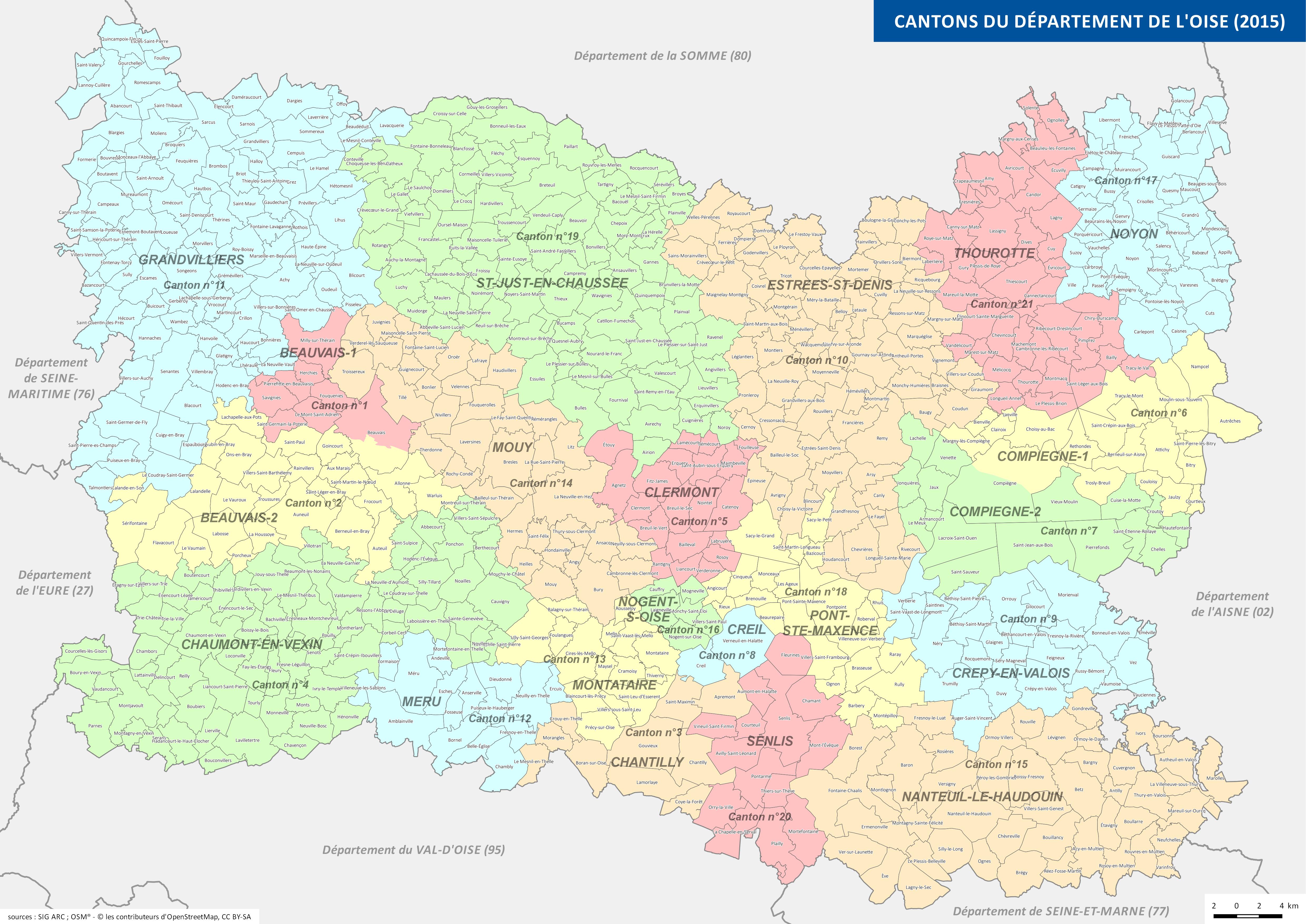
Limites des cantons du département de l'Oise (2015)
Carte du découpage cantonal 2015 sur le territoire du département de l'Oise.
default-legacy
- Date (Publication)
- 2017-01-05T09:00:00
- Presentation form
- Digital map
Point of contact
No information provided.
-
GEMET - INSPIRE themes, version 1.0
-
-
Unités administratives
-
- Theme
-
-
Administratif
-
Limite
-
Périmètre
-
Canton
-
-
GEMET - Concepts, version 2.4
-
-
carte
-
- Use constraints
- Copyright
- Use limitation
-
Utilisation libre sous réserve de mentionner la source (a minima le nom du producteur) et la date de sa dernière mise à jour
- Denominator
- 400000
- Language
- Français
- Topic category
-
- Boundaries
- Description
-
OISE
N
S
E
W
))
- Reference system identifier
- EPSG / RGF93 / Lambert-93 (EPSG:2154) / 7.9
- Distribution format
-
Name Version JPEG
- OnLine resource
-
Protocol Linkage Name WWW:DOWNLOAD-1.0-http--download
http://geo.compiegnois.fr/geonetwork/srv/fre/resources.get?uuid=a2979223-2547-46de-bc37-f832c9b3c7e1&fname=OISE_cantons_2015.jpg&access=public OISE_cantons_2015.jpg
Conformance result
- Date (Publication)
Metadata
- File identifier
- a2979223-2547-46de-bc37-f832c9b3c7e1 XML
- Metadata language
- Français
- Character set
- UTF8
- Hierarchy level
- Dataset
- Date stamp
- 2017-11-28T15:41:01
- Metadata standard name
-
ISO 19115:2003/19139
- Metadata standard version
-
1.0
Metadata author
No information provided.
Overviews
thumbnail
Spatial extent
N
S
E
W
Provided by

Associated resources
Not available