
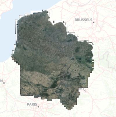
Orthophotographie des Hauts-de-France 2021 - rayonnement visible
Orthophotographie numérique couleur du territoire de la Région Hauts-de-France en 2021, pixel 20cm, produite par l'IGN et retraitée au format COG par Géo2France.
default-legacy
- Date (Creation)
- 2021-11-01
- Citation identifier
- https://www.geo2france.fr/ortho/2021/rvb
- Point of contact
-
Organisation name Individual name Electronic mail address Role Géo2France
Géo2France
Point of contact
-
GEMET - INSPIRE themes, version 1.0
-
-
Ortho-imagerie
-
-
Région
-
-
HAUTS-DE-FRANCE
-
-
Départements
-
-
SOMME
-
NORD
-
OISE
-
PAS-DE-CALAIS
-
AISNE
-
- Theme
-
-
DONNEES OUVERTES
-
ORTHO
-
ORTHOPHOTO
-
SPRD
-
- Spatial representation type
- Grid
- Distance
- 20 cm
- Denominator
- 1000
- Language
-
fre
- Character set
- UTF8
- Topic category
-
- Imagery base maps earth cover
- Description
-
France
- Description
-
HAUTS-DE-FRANCE
))
- OnLine resource
-
Protocol Linkage Name OGC:WMS
https://www.geo2france.fr/geoserver/ign/ows 2021_R32_Ortho_0m20_RVB_COG
WWW:LINK-1.0-http--related
https://geoservices.ign.fr/bdortho Description BD ORTHO
WWW:LINK-1.0-http--link
https://geoservices.ign.fr/telechargement Téléchargements des données source IGN
- Hierarchy level
- Dataset
Conformance result
- Title
-
-- Titre d'une spécification à laquelle la série de données est conforme ou non --
- Date (Publication)
- 2000-01-01
- Explanation
-
-- Information sur l'évaluation de la conformité (non INSPIRE) --
- Pass
- Statement
-
Image au format GeoTIFF-COG produite à partir des dalles IGN jpeg2000.
Metadata
- File identifier
- b0a3f76e-822c-4130-9c6d-49870d0448cd XML
- Metadata language
- Français
- Character set
- UTF8
- Hierarchy level
- Dataset
- Hierarchy level name
-
Précision sur le niveau de hiérarchie (non INSPIRE)
- Date stamp
- 2024-08-02T14:39:28.316016Z
- Metadata standard name
-
ISO 19115:2003/19139
- Metadata standard version
-
1.0
- Metadata author
-
Organisation name Individual name Electronic mail address Role Géo2France
Géo2France
Point of contact
)))