
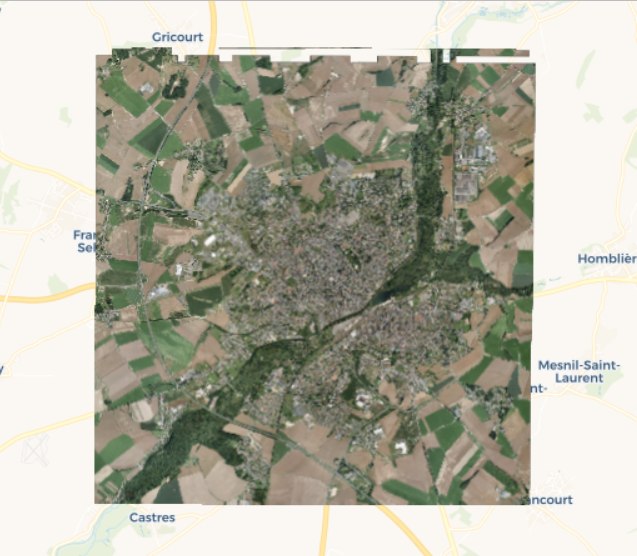
Orthophotographie de l'agglomération de Saint-Quentin (2012)
Photographies aériennes ortho-rectifiées de juillet 2012 couvrant l'agglomération de Saint-Quentin (rayonnement dans le domaine visible).
La résolution des images est de 7,5 cm (taille équivalente des pixels une fois projetés sur le sol).
default-legacy
- Date (Creation)
- 2012-07-01
- Citation identifier
- http://www.agglo-saint-quentin.fr/data/ortho/agglo-saint-quentin-ortho-2012
- Point of contact
-
Organisation name Individual name Electronic mail address Role Communauté d'Agglomération de Saint-Quentin
Point of contact Aerodata France
Author
-
GEMET - Concepts, version 2.4
-
-
photographie
-
photographie aérienne
-
- Theme
-
-
orthophotographies
-
images aériennes
-
données ouvertes
-
-
GEMET - INSPIRE themes, version 1.0 INSPIRE themes
-
-
Ortho-imagerie
-
-
EPCI
-
-
CA de Saint-Quentin
-
- Use limitation
-
Licence Ouverte - http://www.etalab.gouv.fr/licence-ouverte-open-licence
- Access constraints
- Other restrictions
- Use constraints
- License
- Other constraints
-
Pas de restriction d’accès public
- Spatial representation type
- Grid
- Distance
- 0.075 m
- Language
-
fre
- Character set
- UTF8
- Topic category
-
- Imagery base maps earth cover
- Description
-
CA de Saint-Quentin
))
- Reference system identifier
- EPSG / RGF93 / CC49 (EPSG:3949) / 7.9
- OnLine resource
-
Protocol Linkage Name OGC:WMS
https://www.geo2france.fr/geoserver/agglo_st_quentin/ows?service=WMS&request=GetCapabilities agglo_st_quentin_ortho_2012_vis
- Hierarchy level
- Dataset
- Statement
-
Photographies aériennes ortho-rectifiées de juillet 2012 couvrant l'agglomération de Saint-Quentin (rayonnement dans le domaine visible).
La résolution des images est de 7,5 cm (taille équivalente des pixels une fois projetés sur le sol).
Réalisation : Aerodata
Metadata
- File identifier
- bf00e6af-36de-4970-9492-d20a7e8511bd XML
- Metadata language
- Français
- Character set
- UTF8
- Hierarchy level
- Dataset
- Hierarchy level name
-
Précision sur le niveau de hiérarchie (non INSPIRE)
- Date stamp
- 2022-12-14T15:00:03.817245Z
- Metadata standard name
-
ISO 19115:2003/19139
- Metadata standard version
-
1.0
- Metadata author
-
Organisation name Individual name Electronic mail address Role Géo2France
Point of contact
)))