Réseau régional des véloroutes et voies vertes (SR3V) des Hauts-de-France - SRADDET 2020
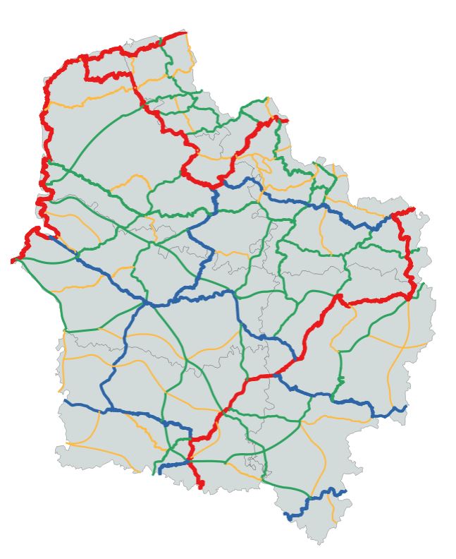
Tracé du réseau Véloroutes et Voies Vertes de la région. Le SR3V a désormais sa place dans le SRADDET afin de prioriser les itinéraires cyclables stratégiques à l’échelle régionale. Promouvoir les mobilités douces, présente de nombreux avantages pour l'avenir (flexibilité, santé, impact positif sur le cadre de vie, et sur l’environnement).
Cette donnée est la représentation schématique du SR3V à la date de vote du SRADDET (approuvé par arrêté préfectoral le 4 août 2020). Le tracé a été affiné en février 2021.
Pensez à consulter les recommandations d'usage jointes en ressources
https://sig.hautsdefrance.fr/ext/opendata/Sraddet2020/precisions_biodiversite.pdf
default-legacy
- Date (Creation)
- 2020-07-02
- Date (Revision)
- 2021-02-19
- Citation identifier
- fr-200053742/2019/srradet/sr3v
- Status
- Completed
- Point of contact
-
Organisation name Individual name Electronic mail address Role Région Hauts-de-France
Point of contact
- Maintenance and update frequency
- As needed
- Keywords
-
-
SCHEMA REGIONAL D'AMENAGEMENT DE DEVELOPPEMENT DURABLE ET D'EGALITE DES TERRITOIRES
-
SRADDET
-
INFRASTRUCTURE
-
SCHEMA REGIONAL
-
EUROPE
-
POLITIQUE REGIONALE
-
VELOROUTE
-
CYCLISTE
-
SR3V
-
VOIE VERTE
-
MOBILITE
-
DEVELOPPEMENT DURABLE
-
AMENAGEMENT DU TERRITOIRE
-
DONNEE OUVERTE
-
-
Thèmes - SIG - HdF
-
-
TRANSPORT
-
-
GEMET - INSPIRE themes, version 1.0
-
-
Réseaux de transport
-
-
Région
-
-
HAUTS-DE-FRANCE
-
-
Départements
-
-
PAS-DE-CALAIS
-
NORD
-
AISNE
-
OISE
-
SOMME
-
- Use limitation
-
Utilisation libre sous réserve de mentionner la source (a minima le nom du producteur) et la date de sa dernière mise à jour
- Use limitation
-
Données ouvertes
- Use constraints
- Other restrictions
Spatial resolution
- Denominator
- 150000
- Language
-
fre
- Character set
- UTF8
- Topic category
-
- Transportation
))
- Distributor contact
-
Organisation name Individual name Electronic mail address Role Conseil régional Hauts-de-France
Point of contact
- OnLine resource
-
Protocol Linkage Name WWW:LINK-1.0-http--link
https://sig.hautsdefrance.fr/ext/opendata/Sraddet2020/transp_sr3v.csv Tableau de données (transp_sr3v)
OGC:WMS
https://qgisserver.hautsdefrance.fr/cgi-bin/qgis_mapserv.fcgi?MAP=/var/www/data/qgis/applications/sraddet_2020_08.qgz transp_sr3v
OGC:WFS
https://qgisserver.hautsdefrance.fr/cgi-bin/qgis_mapserv.fcgi?MAP=/var/www/data/qgis/applications/sraddet_2020_08.qgz transp_sr3v
WWW:LINK-1.0-http--link
https://sig.hautsdefrance.fr/ext/opendata/Sraddet2020/transp_sr3v.zip Shapefile SR3V
WWW:LINK-1.0-http--link
https://sig.hautsdefrance.fr/ext/opendata/Sraddet2020/precisions_biodiversite.pdf Recommandations d'usage
- Hierarchy level
- Dataset
Conformance result
- Date (Publication)
- 2020-06-10
- Explanation
-
-- Information sur l'évaluation de la conformité (non INSPIRE) --
- Pass
- Statement
-
Source Région Hauts-de-France
Donnée : représentation schématique du SR3V à la date de vote du SRADDET (approuvé par arrêté préfectoral le 4 août 2020). Le tracé a été affiné en février 2021.
Metadata
- File identifier
- e7b778d7-2dce-421d-b882-219bb998ef51 XML
- Metadata language
- Français
- Character set
- UTF8
- Hierarchy level
- Dataset
- Hierarchy level name
-
Précision sur le niveau de hiérarchie (non INSPIRE)
- Date stamp
- 2024-12-08T21:35:24.217865Z
- Metadata standard name
-
ISO 19115:2003/19139
- Metadata standard version
-
1.0
- Metadata author
-
Organisation name Individual name Electronic mail address Role Région Hauts-de-France
Point of contact
Overviews
Spatial extent
Provided by