 Géo2France
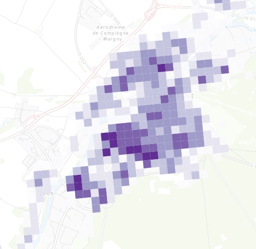
INSEE - Densité de population (2010)
Densité de population en nombre d'individus par hectare, par "carreau INSEE" en Région Hauts-de-France.
Le "carreau" est l'objet élémentaire des données carroyées à 200 mètres de l'INSEE (Millésime 2010).
default-legacy
- Alternate title
-
insee_ind_ha
- Date (Creation)
- 2020-09-18
- Citation identifier
- 2049f1c2-a7f0-459a-89a5-27788b2c5ef5
- Point of contact
-
Organisation name Individual name Electronic mail address Role Géo2France
Géo2France
contact@geo2france.fr
Point of contact
- Keywords
-
-
POPULATION
-
INSTITUT NATIONAL DE LA STATISTIQUE ET DES ETUDES ECONOMIQUES
-
DEMOGRAPHIE
-
INSEE
-
DONNEE OUVERTE
-
-
Région
-
-
HAUTS-DE-FRANCE
-
- Spatial representation type
- Vector
- Distance
- 200 http://standards.iso.org/ittf/PubliclyAvailableStandards/ISO_19139_Schemas/resources/uom/ML_gmxUom.xml#m
- Language
- Français
))
- Geometric object type
- Complex
- Geometric object count
- 150670
- OnLine resource
-
Protocol Linkage Name WWW:LINK-1.0-http--link
https://www.data.gouv.fr/fr/datasets/donnees-carroyees-a-200-m-sur-la-population/ Métadonnées INSEE - data.gouv.fr
WWW:LINK-1.0-http--link
https://www.insee.fr/fr/statistiques/2520034 insee.fr - données carroyées à 200 mètres
WWW:LINK-1.0-http--link
https://www.google.fr/url?sa=t&rct=j&q=&esrc=s&source=web&cd=2&ved=0ahUKEwiO7-e20qLZAhVE7BQKHWU7DRwQFgg2MAE&url=https%3A%2F%2Fwww.insee.fr%2Ffr%2Fstatistiques%2Ffichier%2F2520034%2Fdonnee-carroyees-documentation-generale.pdf&usg=AOvVaw23DGMDgbpfAt_WkAENe3eG Documentation générale - données carroyées
WWW:LINK-1.0-http--link
https://www.insee.fr/fr/statistiques/fichier/2520034/documentation-complete-donnees-a-200m-1.pdf Documentation complète - données carroyées à 200 mètres
OGC:WMS
https://www.geo2france.fr/geoserver/insee/ows insee_ind_ha
OGC:WFS
https://www.geo2france.fr/geoserver/insee/ows insee_ind_ha
- Hierarchy level
- Dataset
Quantitative result
- Value
- Consistency has not been evaluated
- Statement
-
Source : données carroyées à 200 mètres de l'INSEE (carreaux).
Mise en ligne et représentation : Géo2France
Metadata
- File identifier
- urn:isogeo:metadata:uuid:2049f1c2-a7f0-459a-89a5-27788b2c5ef5 XML
- Metadata language
- Français
- Character set
- UTF8
- Hierarchy level
- Dataset
- Date stamp
- 2021-01-25T14:50:08
- Metadata standard name
-
ISO 19115 Geographic Information - Resource
- Metadata standard version
-
2003/Cor.1:2006
- Metadata author
-
Organisation name Individual name Electronic mail address Role Géo2France
Géo2France
contact@geo2france.fr
Point of contact
Overviews
Spatial extent
Provided by
