 Géo2France
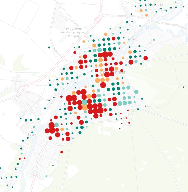
INSEE - Part des ménages propriétaires (2010)
Part des ménages propriétaires en % du nombre total de ménages par "rectangle INSEE", en Région Hauts-de-France. La taille du cercle représente le nombre de total des ménages. Les aplats de couleurs représentent la part des ménages propriétaires dans la population totale des ménages. Le "rectangle" est l'objet élémentaire des données carroyées à 200 mètres de l'INSEE relatives aux ménages (Millésime 2010).
default-legacy
- Alternate title
-
insee_men_prop
- Date (Creation)
- 2020-09-18
- Citation identifier
- dff71c19-d451-4b0b-ada5-32ac2bd7ce4d
- Point of contact
-
Organisation name Individual name Electronic mail address Role Géo2France
Géo2France
contact@geo2france.fr
Point of contact
- Keywords
-
-
INSTITUT NATIONAL DE LA STATISTIQUE ET DES ETUDES ECONOMIQUES
-
INSEE
-
LOGEMENT
-
MENAGE
-
REPARTITION DE LA POPULATION
-
DONNEE OUVERTE
-
-
Région
-
-
HAUTS-DE-FRANCE
-
- Spatial representation type
- Vector
- Distance
- 200 http://standards.iso.org/ittf/PubliclyAvailableStandards/ISO_19139_Schemas/resources/uom/ML_gmxUom.xml#m
- Language
- Français
))
- Reference system identifier
- urn:ogc:def:crs:EPSG:2154
- Geometric object type
- Complex
- Geometric object count
- 65814
- OnLine resource
-
Protocol Linkage Name WWW:LINK-1.0-http--link
https://www.insee.fr/fr/statistiques/2520034 insee.fr - données carroyées à 200 mètres
WWW:LINK-1.0-http--link
https://www.insee.fr/fr/statistiques/fichier/2520034/documentation-complete-donnees-a-200m-1.pdf Documentation complète - données carroyées à 200 mètres
WWW:LINK-1.0-http--link
https://www.google.fr/url?sa=t&rct=j&q=&esrc=s&source=web&cd=2&ved=0ahUKEwiO7-e20qLZAhVE7BQKHWU7DRwQFgg2MAE&url=https%3A%2F%2Fwww.insee.fr%2Ffr%2Fstatistiques%2Ffichier%2F2520034%2Fdonnee-carroyees-documentation-generale.pdf&usg=AOvVaw23DGMDgbpfAt_WkAENe3eG Documentation générale - données carroyées
WWW:LINK-1.0-http--link
https://www.data.gouv.fr/fr/datasets/donnees-carroyees-a-200-m-sur-la-population/ Métadonnées INSEE - data.gouv.fr
OGC:WMS
https://www.geo2france.fr/geoserver/insee/ows insee_men_prop
OGC:WFS
https://www.geo2france.fr/geoserver/insee/ows insee_men_prop
- Hierarchy level
- Dataset
Quantitative result
- Value
- Consistency has not been evaluated
- Statement
-
Source : données carroyées à 200 mètres de l'INSEE. Représentation et mise en ligne : Géo2France
Metadata
- File identifier
- urn:isogeo:metadata:uuid:dff71c19-d451-4b0b-ada5-32ac2bd7ce4d XML
- Metadata language
- Français
- Character set
- UTF8
- Hierarchy level
- Dataset
- Date stamp
- 2021-01-25T14:53:30
- Metadata standard name
-
ISO 19115 Geographic Information - Resource
- Metadata standard version
-
2003/Cor.1:2006
- Metadata author
-
Organisation name Individual name Electronic mail address Role Géo2France
Géo2France
contact@geo2france.fr
Point of contact
Overviews
Spatial extent
Provided by
